National Hurricane Center tracking system in Caribbean. Will it become Tropical Storm Patty?
The National Hurricane Center is tracking a broad area of low pressure in the Caribbean Sea that could become a tropical depression late this week or over the weekend.
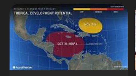
AccuWeather weather forecasters have been warning since last week about the potential for a tropical depression or storm to develop in the western Caribbean and currently give the system a high chance for development between Oct. 31 and Nov.4.
There’s also another area with potential for development over the weekend or early next week. This one is located east-southeast of Florida.
The next named storms of the 2024 Atlantic hurricane season will be Patty and Rafael.
Tropical Storm Patty? Will Florida see another storm or hurricane?
Two conditions that have played a role throughout this hurricane season could bring yet another depression or tropical storm: low wind shear and very warm water.
Even a hurricane is possible, under the right conditions, according to AccuWeather Alex DaSilva, lead hurricane expert, in a telephone interview Monday morning.
“Storms in the Caribbean usually move to the north or northeast in November. This means that residents and visitors along the Southeast Coast will have to keep a close eye on development,” cautioned DaSilva.
November brings tropical development closer to Florida, US
“As we move into early November, the focus for tropical development shifts closer to the United States. Typically, the areas of focus late in the season are the Caribbean and off the Southeast coast,” said AccuWeather Lead Hurricane Expert Alex DaSilva.
Another area to watch located southeast of Florida, US
This area currently has a low chance for development. It could form along the end of a cold front that will move off the East Coast late this week, according to AccuWeather.
“If an area of low pressure forms and is not attached to the front, then the development potential would increase.”
Tropical depression could form late this week in Caribbean
A broad area of low pressure is likely to develop over the southwestern Caribbean Sea in a few days.
Gradual development is possible thereafter, and a tropical depression could form late thisweek or over the weekend while the system begins to drift northward or northeastward toward the central Caribbean Sea.
Formation chance through 48 hours: low, near 0 percent.
Formation chance through 7 days: medium, 40 percent.
What else is out there and how likely are they to strengthen?
The National Hurricane Center also is watching four tropical waves:
Eastern Atlantic: A low amplitude tropical wave west of Cabo Verde is along 35W, south of 15N, moving westward at 11 to 17 mph.
East of Leeward Islands: A tropical wave is along 52W, south of 17N, moving westward at 11 to 17 mph.
Eastern Caribbean Sea: A tropical wave is moving across the eastern Caribbean. Its axis is along 68W and extends southward into western Venezuela.
Southwestern Caribbean: Another tropical wave has reached the Caribbean plains of Nicaragua. Its axis is along 84W, south of 18N.
Leave a Reply